Just got back from a hectic week or so in the UK on business.
Most of my time was spent a stone’s throw from Heathrow at the Stockley Park HQ of Canon Europe. As I wandered between the two Canon offices in the business park, I realised that I’d actually visited the Apple offices there years before in a previous life. At the time they were pushing their server business to us as a reseller. Seems like another world… definitely pre-iPod!
On the Thursday I got to drive to Reigate, which was an experience. In the 15 or so years I’ve been away, it would seem that small town England has been designated as a car-park. Every place I visited was blighted with cars parked on both sides of the street, leaving the narrowest of channels for everything else. Cars, lorries and buses. These streets are essentially just tarmacked-over cart tracks. Add to that the ubiquitous roadworks and even the shortest of journeys can take a disproportionately long (and unpredictable) time. I didn’t mind though. I was in the great company of a Dutch colleague who shared my dubious sense of humour and the time passed quickly. I really enjoyed getting used to driving on the left again. In a manual car. A diesel no less. It behaves very differently to a petrol car and is unforgiving if you skip a gear on the way up. Not enough revs, it seems. Thankfully muscle memory still seems to operate even at my age, and I didn’t come close to making any potentially fatal errors of lane selection. Or stalling! I only came close to getting in the wrong side of the car once too. Conversely, since I got home I have tried depressing the non-existent clutch in my automatic several times. I have to say though, the electronic hand-brake was a bit of a bugger to get used to. Unlike our manual HR-V it doesn’t automatically engage when you come to a complete foot brake stop, so if you don’t apply it (like in the old days) your car rolls back. Great for perfect hill starts though. Not sure what happens if your battery goes flat when you’re parked on a hill though…
It was also great to see so much variety of cars on the road too. Things are so limited here in Canada with the huge pressure from the US manufacturers. I had a Citroën Picasso C4.

Citroën Picasso
Everything was electronic – not just the hand-brake. I think the speedo was broken though. Surely diesel cars don’t do 90 mph do they? (145 km/hr in new money). The wipers came on when they felt the windscreen was a little moist. The headlights came on when they thought it was dark enough. Pretty much everything except the expected GPS. “SatNav” as it’s known over there is a chargeable option on hire cars. I wasn’t going to pay for what my phone offered for free.
The Canon UK office in Reigate had a retro red LED display in reception to show visitors how much power they were saving by using solar panels on the roof. Great idea… presumably by someone who doesn’t actually live in the UK. It rains about the same as in BC. The numbers say it all really…

Solar Energy in Canon UK, Reigate
Yup: solar energy only works in places where the sun shines… they could have saved power by just painting zeros on a piece of cardboard.
After performing my duties in the office I took the opportunity to visit my parents in Yorkshire for a day, so I headed north and somehow beat most of the Friday night exodus from London on the M1. After a peaceful night’s sleep we drove to Malham on Saturday morning, visiting the cove there. I hadn’t been since I was a kid. It was incredible how peaceful the Dales are. As a National Park, the building and therefore traffic is restricted and it shows. It was just like I remembered it 40 years ago. Every other vehicle you see is STILL a Land Rover Defender! And not for show, either. These 4x4s earn their keep on the many farms.
As we entered the village, visitors cars were already parking along the side of the road (see above!), which indicated the National Park car-park closer to the village centre was likely already full. The view over the drystone wall to the hills in the west were stunning. This was a very typical view – sheep behind ancient drystone walls, gently rolling hills occasionally broken by limestone scars… and a sprinkling of snow on “the tops.” The tops in this case being Kirkby Fell.

West from Malham
One of the first things you pass as you enter the village from the South is the Wesleyan Methodist chapel, built in 1866. Just for context, that’s when the Colony of British Columbia and the Colony of Vancouver Island were united as British Columbia, with the capital at Victoria. 20 years before the town of Granville was incorporated as “The City of Vancouver”.
It was a typical functional building, a style familiar from my childhood and still common in many rural areas of Yorkshire. (Built to last, as they say!)

Malham chapel
As we walked through the village we came to the little traffic island with a road sign dating from years past. This “fingerpost” style was made redundant in the ’60s as part of the Worboys committee review. Note at the the top it says “Yorks W.R.” for Yorkshire – West Riding. The Riding has long since been dissolved in favour of simply West Yorkshire. As I left the country 15 years ago, the debate lingered on about whether the political entity of “Humberside” was still philosophically part of Yorkshire… wars have been fought over less.
Note also the 6 digit number at the lower part of the ring (you might need to click on the photo to expand it in order to see clearly)… this is an Ordnance Survey grid reference added as an experiment in West Yorkshire road signs to help the lost traveller to figure out where he was. The Ordnance Survey was a mapping project originally undertaken to help with the placing of guns (yup – a survey for ordnance) in Scotland in the wake of the Jacobite rebellion in 1745. It is now a comprehensive mapping scheme for the entire UK. Sometimes prefixed by a letter code (SD in this case) so you know which map or “sheet” to look for the grid reference on, it identifies your location to within a few metres.

Fingerpost – Malham
Malham’s sign gives a reference of 900628 which gridreferencefinder.com confirms is where it claims to be. The extra accuracy of modern satellite mapping allows a 10 figure version of a grid reference to be given if you’re REALLY specific. Of course “just up the road from the Buck Inn in Malham” worked pretty well too!

GridReferenceFinder.com: Malham
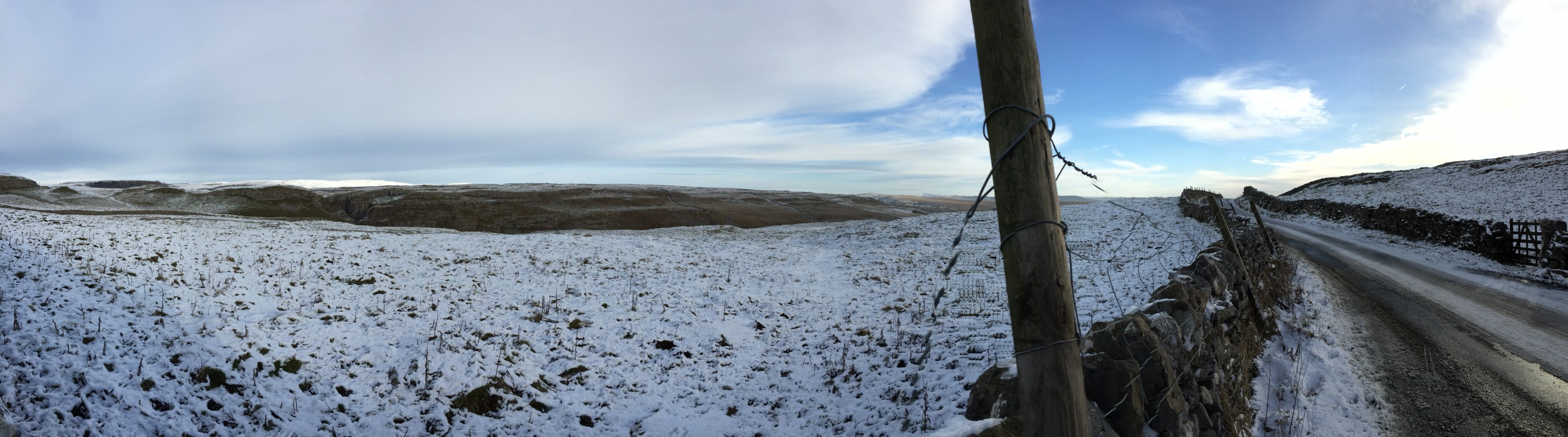
As we headed NW on the Cove Road out of the village towards the Pennine Way footpath, we were rewarded with more stunning views (to the East this time) of the typical sheep enclosures in much of the Dales – the mosaic of drystone walls.

Shorkley Hill to the NE of Malham village

Panorama to the East and Shorkley Hill
The cove was already visible as part of a broader limestone feature. It’s to the right in the photo below. From this distance though it was just a temptation. The winter sun was bright and the air crisp. A challenge to avoid shadows in the photos!

Malham Cove from the start of the path.
Time for some artsy photography now. To the left of the path was a road. Beyond that was a field with a small barn called – logically enough – High Barn. SD896633 just for “reference” :). Separating all these features were drystone walls. The layered effect struck me as worthy of capture. You can see we’re steadily gaining height and we’re right at the snowline, such as it is, after the light sprinkling.

High Barn, Malham
The path we were on from the village to the cove was actually part of the Pennine Way. We were only walking a half mile or so of it, but it stretches 267 miles up the backbone of Britain. It used to be on my “to do” list, but I guess that’s no longer realistic.

It’s the way we do things in the Pennines
As we got closer, the cove became more dominant and the black streaks it’s famous for become more noticeable. In Charles Kingsley’s Victorian book The Water-Babies these are attributed to the main character Tom (a boy chimney sweep) clambering down and leaving soot marks.

Tom’s sooty marks on the face of Malham Cove
At 80m high it’s very popular with climbers, but not on this chilly winter’s day. There was ice around and my father learnt to his cost that even a small amount is enough to lose one’s balance very suddenly. As we progressed towards the cove itself the sheep seemed pretty nonchalant at our intrusion. I inexplicably had a sudden desire for lamb shank and new potatoes…

Shaun? Is that you?
Limestone is very hard-wearing, but glaciers make short work of it over the millennia. Slabs of it had been used to bridge the small beck flowing from the foot of the cove, and pools of water had frozen in the hollows making a most interesting effect.

Ice in the limestone footbridge
The power of the glaciers to move huge chunks of rock around and wear away at the rock face defies imagination. I am always calmed in the face of such natural, slow-moving power.

One scoop of lime or two?

Mother and daughter?
Finally we were there and the sheer scale was apparent. It seems that during the harsh rains at Christmas which caused much flooding in the area, this long defunct waterfall once more gushed and was briefly the UK’s highest “single fall” waterfall once more. The sheer power could only be imagined on this lovely sunny day though.

The foot of Malham Cove
The pleasant stroll back offered even more views of this lovely, relaxing place. I could feel the vitality of it soaking into my bones. So calming. Time stops in such places.

Wall with a view
Back in the village I was surprised to see an emergency defibrillator on the wall of a building. There was a push-button key lock on it, and in an emergency you call 999 and tell them the unit number and they give you the code to open it and hopefully revive someone who’s heart has stopped. Plainly there’s quite a risk from hiking in these parts! The pub however seemed very welcoming to hikers – boots and all! “A warm Yorkshire welcome” says the sign… indeed! Shame about the missing apostrophe on the sandwich-board sign though. 😦

AED on the wall… just in case!

My two favourite beers in one place! Timmy Taylor’s and Theakston’s

All welcome… boots included!
Just for context, here’s a snap from Google Maps to show the village (and thankfully it IS still a village – there is little development allowed) to the South, the cove to the North. See the pattern of drystone walls – they’re pretty much everywhere in the lower Dales. The limestone terraces are quite clear even on this satellite image.

Google Maps: Malham, Yorkshire
It was now time for lunch, so we headed up the road to the NW to drop down via Langcliffe into Settle. Even this gentle increase in elevation was enough to take us above the snowline, and we briefly stopped to take a few photos of the stark beauty that is The Yorkshire Dales.

Sheep pen on the moor near Malham Tarn
Panorama back towards Malham from up on the moor

Stile over the wall to keep the sheep in. Hikers can’t forget to close it like they can with a gate!

Long and winding road back to Malham from up on the moor
One more stop on the road to Langcliffe and Settle. Here we were looking to the North-West and could clearly see the magnificent Pen-y-Ghent to the North. It was a great way to end the trip out and I felt totally revitalised after only a few short hours in this amazing place. You’ll likely need to click on the first pano. shot to make it clear enough to see Pen-y-ghent on the far right. It was about 5 miles away.

Pano looking North from Langcliffe road. Pen-y-Ghent to the far right in the distance

Just chillin… as sheep on the moors are wont to do.

Pen-y-ghent looking as magnificent as ever it did.
Once we were home, I treated the folks to pork pie with egg. For no other reason than I’ve never seen it here in BC and it reminded me of my childhood. If you fancy it yourself, try the BBC recipe here.

Pork pie with an egg in the middle… perfect end to the day


[…] was now the second in two days – the previous one being in sleepy Malham in Yorkshire (see previous post). To the left of the phone box, you can see an old WWII sea mine. You can just see the plunger […]
Everything is so beautiful and natural! Never had a pie with an egg inside..but I like pie and I like eggs. I need to try this…
Well… the landscape has been altered by hundreds of years of farming, but it SEEMS more natural, doesn’t it?
Compared to the views I usually see, definitely so! I guess it’s more natural relative to what a city person would usually see 🙂
“I think the speedo was broken though. Surely diesel cars don’t do 90 mph do they?”
Well, when the speed limit’s 70mph, I guess there’s just no way to know. 😉
Love the Dales, beautiful part of the country. And very interesting about the OS’s connection to the Jacobite uprising. I’d never heard that before.
I remember when I did my “Advanced driving course” with DuPont, the trainer referred to the “National speed limit applies” sign (white circle with black slash) as “the GLF sign”. I leave it to the reader what one was encouraged to go like…
As for the OS, it was one of those nuggets of information I remembered from my time at school, and the date was supplied by uncle Wikipedia.
I vaguely remember something about Macadam roads too (loose stones packed in layers) that revolutionised the road system in the early 1800’s. The addition of tar leading to the ubiquitous “tarmac”.